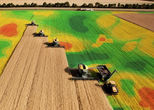
Geographic Information System in Agriculture

According to the latest report by Emergen Research. The global Geographic Information System (GIS) software in agriculture market size reached USD 4.04 Billion in 2020 and is expected to register a revenue CAGR of 12.8% during the forecast period, Increasing awareness regarding risks due to food insecurity and increasing need for precision farming are key factors projected to support market revenue growth between 2021 and 2028. In addition, increasing demand for GIS software for real-time mapping will boost revenue growth of the market. Water availability and management are major issues in agriculture, and better real-time land data is important in solving this problem. GIS software provides a smart solution to the problem. Drones and satellite images can effectively manage and monitor soil and land conditions. GIS software entails use of Soil Moisture Ocean Salinity (SMOS), and monitors vegetation growth using Landsat imagery and Normalized Difference Vegetation Index (NDVI), and others, to analyse crop productivity, monitor drought conditions, and potential of flooding.
The report is formulated through extensive primary and secondary research and is curated with an intent to offer the readers and businesses a competitive edge over other players in the industry. The report sheds light on the minute details of the Geographic Information System Software in Agriculture industry pertaining to growth factors, opportunities and lucrative business prospects, regions showing promising growth, and forecast estimation till 2028.
On-cloud segment is expected to register a substantially rapid revenue CAGR during the forecast period due to increasing need for real-time geospatial data. On-cloud GIS software allows farmers and land managers to capture real-time data of the land directly from anywhere at any time.
Crop monitoring segment is expected to register a significantly robust revenue growth rate over the forecast period due to rising need for crop stress information. Crop stress information includes poor water availability, extreme temperatures, nutrient deficiency, uncontrolled use of chemicals, fungal and bacterial infections, and others.
Asia Pacific market is expected to register a considerably large revenue share over the forecast period due to robust presence of major market players providing GIS software such as Topcon Corporation and SuperMap Software Co. Ltd. among others in countries in the region.
The report also studies the key companies of the Geographic Information System Software in Agriculture market along with analysis of their business strategies, M&A activities, investment plans, product portfolio, financial standing, gross profit margin, and production and manufacturing capacities. Some players analyzed in the report are: Oracle Corporation, Hexagon AB, Autodesk Inc., Takor Group Ltd, Trimble Inc., Topcon Corporation, SuperMap Software Co. Ltd., Parrot SA, Earth Observing System (EOS) Data Analytics Inc., and Geosoft Inc.
It focuses on the recent mergers & acquisitions, joint ventures, collaborations, partnerships, licensing agreements, brand promotions, and product launches, among others. The report also provides details about the company overview, business expansion plans, product portfolio, manufacturing and production capacity, global market position, financial status, and consumer base.

The report further divides the Geographic Information System Software in Agriculture market into key segments such as types, applications, end-user industries, technologies, and key regions of the market. The report also sheds light on the segment and region exhibiting promising growth in the Geographic Information System Software in Agriculture market.
Deployment Outlook (Revenue, USD Billion; 2018–2028)
On-premise
On-cloud
Application Outlook (Revenue, USD Billion; 2018–2028)
Crop Monitoring
Irrigation Monitoring
Soil Analysis
Others
Understanding the market size
The size of the Geographic Information System Software in Agriculture market is viewed in terms of the Share of Market, Total Available Market as well as Served Available Market. Not only does the study present the combined revenue for a particular market but also the market size for a specific geographic region. Analysis of percentage or the size of the Total Available Market based on the type of product, technology, regional constraints and others form an important part of the Geographic Information System Software in Agriculture report.
Regional Segmentation
North America (U.S., Canada)
Europe (U.K., Italy, Germany, France, Rest of EU)
Asia Pacific (India, Japan, China, South Korea, Australia, Rest of APAC)
Latin America (Chile, Brazil, Argentina, Rest of Latin America)
Middle East & Africa (Saudi Arabia, U.A.E., South Africa, Rest of MEA)
It further offers a comprehensive coverage of the strategic alliances such as mergers and acquisitions, joint ventures, collaborations, product launches, brand promotions, and partnerships, among others. Key strategic alliances for product development and advancements is expected to add traction to market growth going ahead. The report also covers an in-depth analysis of the key competitors of the market along with their growth strategies and business expansion plans.
Source: https://www.google.com/amp/s/www.einnews.com/amp/pr_news/562339036/geographic-information-system-software-in-agriculture-market-size-share-development

 Previous Post
 Next Post